
Contents
1 Introduction
2 Montreal, Wednesday April 28
3 Honolulu, Wednesday April 28
4 Kona, Thursday, April 29
5 Spencer Beach Park, Kawaihae, Friday, April 30
6 Spencer Beach Park, Kawaihae, Saturday, May 1
7 Keo-kea Beach Park, Sunday, May 2
8 Keo-kea Beach Park, Monday May 3
9 Honoka`a, Tuesday, May 4
10 Waipi`o Valley, Wednesday, May 5
11 Waipi`o Valley, Thursday, May 6
12 Kalopa State Park, Friday, May 7
13 Hilo, Saturday, May 8
14 Hilo, Sunday, May 9
15 Hilo, Monday May 10
16 Volcanoes National Park, Tuesday, May 11
17 Volcanoes National Park, Wednesday, May 12
18 Volcanoes National Park, Thursday, May 13
19 Volcanoes National Park, Friday, May 14
20 Discovery Harbor, Saturday, May 15
21 Captain Cook, Sunday, May 16
22 Captain Cook, Monday, May 17
23 Punalu`u, Tuesday, May 18
24 Hilo, Wednesday, May 19
25 Hilo, Thursday, May 20
26 Hilo, Friday, May 21
27 Mauna Kea (9000'/2800m), Saturday, May 22
28 Mauna Kea (9000'/2800m), Sunday, May 23
29 Honolulu, Monday, May 24
30 Honolulu, Tuesday, May 25
31 Honolulu, Wednesday, May 26
32 Montreal, Thursday, May 27
33 Bicycle Touring and Camping on the Big Island
34 Maps
This year I am really going to have a ``Tour de l'isle'' - the Big Island of Hawaii. Last year's ``Tour de l'isle'' of Australia was impossible. Australia is a ``Really Big Island''.
It is expensive to fly to Honolulu from Montreal - I got a ``special'', on its last day for $1004 (CDN) and struggled for some time to get a cheap flight to Kona. It is possible to buy five interisland tickets from Aloha for $275 (us)1. However they are only valid for a year, and do not allow flights to Molokai. I decided, finally, to get the unrestricted $282 (CDN).
I haven't been on Hawaii since 1976, and never for a whole month. On my very first trip to Hawaii in the mid 60s, I was fortunate enough to see Halema`uma`u2 active, with lava fountains rising 50'plus (15m). I have always wanted to see it again but Madam Pele has remained calm and quiet during all my subsequent visits and during the whole time we lived in Hawaii Kai. Maybe this year!!!
The ``Big Island'' is bigger than all the other ones combined. This is a satellite picture shows the two major mountains, Mauna Loa (Long Mountain) and Mauna Kea (White Mountain), plus several other remnants.
One of my problems camping in the US is getting Camping Gaz fuel for my lantern and stove. It is easy to get white gas or the large Coleman propane canisters in the US but anything else is rather chancy. My good lantern uses Camping Gas and starts with the push of a button. I would like an equivalent one to use in the US but will have to stick to my manual Coleman. The stove is also a problem. The ones for Coleman gas are huge and bulky. For this trip I bought a new Primus multifuel stove that runs on Primus, or Coleman Peak 1, gas canisters, and almost any liquid fuel that burns - white gas, unleaded gasoline, kerosene, diesel fuel. I bought the stove in Toronto when we went down for Jennifer Mackenzie's wedding (Peggy's former roommate), and was learning how to use it when the liquid fuel pump, literally, fell apart. I put it back together, but it fell apart again. This was Tuesday and I was to leave on Wednesday. I took it to La Cordée, a good camping/bicycle/climbing store in Montreal, to see if they had the little lock washer necessary to put it back together. I left it with them, and they phoned back an hour later to say they could not fix it, but since I was leaving almost immediately for Hawaii, they would replace the pump with a new one, even though I did not buy it from them. Caroline was very nice.
This trip is the first for my new bike, another folding Montague. I decided, after last year's trip to Australia that the old one needed to be replaced. I was about to fold it up and put it in the backpack when I noticed a broken spoke. As usual, with a new wheel, I did not have the correct size spoke. Why did it break? I have never ridden it with a full load.
I finally got everything packed, and repacked this morning. The new bike is bigger than the old one so it is harder, again to stuff everything inside. Finally it was all in place, and in the back of Scarlett, Virginia's New Red Beetle. The flight to Toronto was uneventful, except that we had to go all the way to Hamilton to turn around to land against an east wind. This made us a little late. There was only 40 minutes to get my stuff across - they managed it though, because I am now here at the Interisland Terminal, in Honolulu, writing. The highlight of the flight, was, amazingly enough, the movie - ``Star Trek: Insurrection''. I didn't know there was a new Star Trek movie. CP's wines, Cuvée Gallant (Chardonnay and Merlot) from the ``Isle de Beauté?'' in France were in CPs usual, barely drinkable, style. Dinner and snack was acceptable chicken.
I had been warned by Nan Jackson, friends from when we lived here, that they had closed off part of the airport so as to make it harder for the homeless to camp out. It is indeed harder. The spot that I used on my trips to Maui and Kauai is now off limits. There is nothing near an open washroom any more.
However, I did manage to find a power outlet by an Interisland Terminal Entrance, so I am writing without depleting the battery. The terminal, is, of course, closed. While I was writing, a kid, from Germany, with a backpack came by and frantically tried to get in. He said he had a flight just after midnight and wondered how he could check in. I told him that he couldn't have a flight then because nothing was leaving until 5:15am. He insisted, so we looked at his ticket. It was at ``12:45p'' today. He had missed it. Needless to say he was quite distressed. After talking for a while, he decided that waiting until 5:00am when the terminal reopens, was not quite reasonable. He went back to the Backpacker's Hostel and will see the Hawaiian Airlines Ticket office in the morning. His original $180 (us) ticket (HNL/SEA) will probably end up $320 (us) - $100 change penalty and an extra $40 because the flight tomorrow is more expensive.
After about 1/2 hour on my foam pad behind a post, I needed to find a washroom. All the accessible ones that I had found earlier were locked. The one that I finally found open was open only because of an accident of construction. However, it solved the immediate problem. On my way back to the Interisland terminal, this time on the ground floor, I found a nice grassy and protected area under a tree. It was wonderful except that the garbage trucks decided to empty the trash containers at 2:30am. At just after 3:00am, they were apparently finished. Then I was checked out, and deemed harmless by the Airport Security Police. Although, I could have stayed there the rest of the night I was no longer sleepy, and decided to look for some light so I could read. Much to my surprise, the terminal opened at about 3:30am. Now the only problem was that none of the areas with chairs had light.
Gary Boates and his family did better than I, while waiting for their flight to Maui. Gary, his wife Cethlyn (Kelen), and their 6 year old daughter, Aldara are from Acadia University in Nova Scotia. Kelen teaches English and Gary is in charge of the computers and networking for Acadia. They went upstairs into the main terminal, through security again, and stayed, with all the shops ... and a bathroom. They were only moderately hassled going through security because they did not have a boarding pass. It worked out well.
We arrived in Kona (more accurately ``Kailua-Kona'') just before dawn and my bags were waiting before I got to the baggage claim. I left the bike so it would be very easy to put together but had not counted on the fact that the wheels were still not stable. They were very twisted so I spent an inordinate length of time straightening them. I almost despaired of ever getting them straight. They finally were ok and I am about ready to go to Kona. As I was setting up, two of the airport police came over and asked ``Are you having a rummage sale?''. Later, by taking too long, and plugging SAM, my computer, into their power outlet, I apparently irritated the Aloha baggage people into action. John, one the airport police came over and asked ``How long are you going to be?''. I told him I was about to leave, unplugged SAM, disorganized the rest of my stuff into my bags, and started out for Kona. It is still early, 8:40am, and I am here for a month.
Kona was about 9 miles away, on a generous shoulder with the reassuring signs ``Bicyclists use shoulder''. This area is old lava flows, with natural trees just starting to reappear. I saw two ladies gathering Bougainville flowers from trees lining the road. Planted trees are increasing. There was also a field of Plumeria trees, all in bloom, with a sign ``Plumeria Leis for sale''.


Kona starts with light industry developments outside of town and mauka (``towards the mountains''). In the midst of one of the first was a Costco. The village of Kona, around the harbour and down Alii Drive is graciously unspoiled, much the same as it was in 1975 when we arrived in the Kona Harbor on Sea-Flite, the sadly demised, interisland hydrofoil service. The development is mauka of the old center. One of the new shopping centers has a Walmart and Safeway. I provisioned and fueled here. Much to my dismay, I was unable to find Coleman fuel in less than gallon cans3.
Internet access is available in Kona. At the library, you need to make reservations and have a Hawaii Library card. Mine expired 25 years ago. Everyone recommended Zaks. They had seven computers, with rates of $2.75 for the first 15min and $8 an hour if you were on that long. I had to wait. It was full up. When I was able to telnet to INRS, the net was so slow that it was too painful to do anything but reply to email, with rather spastic typing - the echo delay was half to a full line. I did check in with Virginia and Peggy, but did not send my initial progress report.
The 38 miles to Samuel Spencer Beach Park just south of Kawaihae, was on a nice paved shoulder through lava flows of various ages and quality. Some were the remains of very fast liquid rivers with glassy smooth tops (pahoehoe lava), and others were cinder block like from a slow oozing flow (a`a lava4 The different ages showed in the colour - dark black to brown and gray. There were no trees, except those planted as memorials. Tufts of 12in high grass were the first valiant attempts at regeneration.
The flows were also covered with a very interesting graffiti.

People used white coral rocks to create messages on the black lava background. They were the standard ``Keoki loves Nicole'', the ambiguous ``Bran Sean'', and the transitory ``Lisa and ...''. The last line had been erased, and had become a white smudge.
My energy reserves had been completely depleted, even with banana refueling, by the time I reached Kawaihae and I was very glad to go down the hill to the beach park. You are supposed to get a permit for camping at all the beach parks. I had none. I had the misfortune here of arriving just before the park constabulary came by to check. He was quite adamant that I needed a permit. I apparently should have gone 10 miles up the hill to Waimea to get one. When I told him that I had just flown in to Kona that morning with my bike and stuff, he took a look at my bike and tent and said ``What airline would carry that!'' He then took my passport number, said that he would report me, and told me, ``If you are caught again without a permit, you will be banned from all the parks!''. I generally don't know where I will be the following night, and find it impossible to get to a park office during the 8:30am to 10:30am - Waimea, 8:30am to 4:30pm - Kona, and Hilo, when they are open. I am not certain what I will do.
Our campground is home to 8 cats, evidently 3 different litters from last year. They are very cute, but too wary to let me feed them. They much prefer foraging in the garbage cans. They, and the resident mongoose, were a delight though.

It is now dawn, the sun has just come up, and maybe the clouds will go away so I can see Mauna Kea. It was indeed cloudless this morning and remained that way until about noon. The bay in front of us is dead calm - perfect snorkeling time.
After the hassle of last night, I decided I would go up to Waimea to see if I could get a permit.
It was indeed up - all the way. I had just started when one of the road construction crew said ``It's a long way!'' - it wasn't really, but it sure felt like it. I saw my first elevation marker, ``500'/152m'' - both feet and metres were actually shown. The countryside was still dry and grey/blue grass, with fire danger signs, and the occasional tree. At 1000'/300m I was really struggling. It was not really steep, although my perspective on steepness at this time of year is skewed from a season of skiing. At 1500'/450m there was a tinge of green and the new housing developments started. There was a succession of brand new, paved, wide, private roads. At 2000'/600m there was much green, some Parker Ranch cows, and more housing enclaves. I had been banana/trail mix refueling so my general energy reserves were high, but my legs were totally without power - even the smallest slope was a challenge. Waimea is just over 2500'/750m and not finished with the hills even when you get into town. I arrived at about 1:00pm - it took me about just 4+ hours to make the climb. I am going to have to get into much better shape to go up the 14,000 feet to Mauna Kea.
With some difficulty, and the well meaning comment ``I didn't know camping permits were available in Waimea, but, if they are, it must be at ....'', I found the office. The sign in front did indeed say, ``8:30/10:30'' but it was not yet closed. I was able to get permit for the next four days - which should get me back to Kona. After the climb up to Waimea, I decided that the only campground that I could get to was Spencer Beach - it was all down hill. We talked a while, and another park worker, seeing my bike, asked if I had included the Jacuzzi. I also got some good local advice. I was told to ride the Saddle Road from the Hilo side - it was much less steep - and to be very careful coming down on this side.
Waimea5 appears to be an unpretentious town with playgrounds (the wooden palisade type), baseball diamonds and some small shopping centers. The only defining characteristic is that there are an endless supply of ``Parker ????''. I have read that there are some very rich parts of town, but I didn't see them. Perhaps they were up the hills. After stopping in the KTA Superstore for bananas, white corn tortilla chips, and some interesting looking Hawaiian made salsa (it was almost as good as the homemade version of my friend Jean-Charles), I started down the hill. It was 30mph (50kph) most of the way. Occasionally, the wind and a diminished grade slowed me down to 17mph.
I arrived back at about 3:30pm and stopped at Pu`ukohala Heiau at the entrance road. This was Kamehameha's shrine, and battle headquarters while he was conquering the islands. It is quite ruined, and, even so, it is still sacred ground so you can only see it from afar. Since they were about to close the gate (4:00pm), I was told that I had to come back another day to see it, unless I opted to go along a closed road that ran in front. Instead, I went back and set up camp.
Spencer Beach Park is one of the most popular on the Island. Some of the regulars have decided that it is their responsibility to feed the 8 cats. One girl brings cat food, puts it in a dish for them, and retreats a respectful distance - not too far. The cats seem to recognize her as a safe source of food.

When the ranger came by to check my permit, which he was glad to see I had, he told me that he had seen me going up the hill - or rather, stopped, reading.
Before supper, I snorkeled over the coral in the bay - the water was rather murky from the wave action so the fish looked a little faded. I will try gain tomorrow morning before I leave.
Dawn is breaking - it is cloudy. Perhaps we shall have the rain that the people in Waimea were wishing for yesterday - there was none - sun till noon, some clouds, a touch of rain, and then more sun.
I really did a number on my legs yesterday. There was not even enough power left to get up the hill out of the park - without some rest stops - yesterday I struggled up successfully.
The road north was typical coastal up and down - nothing too steep - through grey/blue grass tufts, and now kiawe (mesquite) trees. There had been several burns, and the dead trees were being cut, probably for firewood. The centre of each trunk was a beautiful dark red, with light brown outer heart? wood, about an inch thick. Kiawe trees are quite common, and make off road riding quite dangerous. They have vicious thorns that can easily puncture a tire or a sandal.

My first stop was Lapakahi State Historical Monument. This is an abandoned 600 year old Hawaiian Village. All that was left were some old stone walls surrounding the houses. I found the naming of the trees the most interesting part of the guide. I had forgotten most of the names. This part of the island is now almost devoid of water. During the time of the live village, there was a well. The infamous diversion of the Kohala water supply by the sugar planters in the ``Kohala Ditch'', so lowered the water table that there is nothing available by natural means - even the seasonal rivers are no longer flowing. Now that sugar is being phased out of the islands, and the ditch is being allowed to deteriorate, perhaps the balance will change.
Just a mile up the road was the first alternate Beach Park for tonight - Mahukona. The village of Mahukona is essentially abandoned. It was the terminus for the old Kohala Sugar train, but its harbour and piers have mostly rotted away - and they were all made of concrete. The park consisted of a little patch of ground in front of a small pavilion. There were no outside showers and almost all the water faucets said ``Unfit for drinking!''. The most distressing part though was 8 identical, brand new tents, and a trash can 1/3 full of Budweiser cans.
My next stop was the second alternative, Kapa`a Beach Park. It was even worse than Mahukona. There did not appear to be any water and only porta-potties for bathrooms, and I couldn't even see where the camping area was supposed to be - on to Keo-kea.
Just north of Kapa`a Beach Park, in the space of less than 1/2 mile (1km), the countryside went from desert gray/blue to lush green. This was where I turned the corner from leeward to windward Hawaii. As I continued north (east actually - I didn't notice when that happened - possibly because I was too captivated by the green) it became more tropical - ironwoods, heliconia, and ....
Hawi6, at the top of Kohala, and the end of the Kohala Mountains road was a shear delight. It was delightful ``up-country'' Hawaii. On Maui and Kauai, it has long since disappeared. There were, perhaps, a few more upscale stuff shops than 20 years ago, but the houses and stores had that old up-country architecture. It continued that way to Keo-kea.
I was getting a little tired of bananas and trail mix so I was determined to find a grocery store ``Plate lunch''. Plate lunches are an exotic mix of Polynesian and Japanese food. I saw an appropriately old grocery store up the Kohala Mountains road, but was diverted by a small Hot Malasada stand across the street. Malasadas are a Portuguese light bread dumpling, deep fried in oil, and rolled in sugar. I told the folks that I was delighted and that I had not had Malasadas for 20 years. There was a hint of skepticism in the question ``Where?''. I said ``Kaimuki'' and they immediately replied, ``Oh, Leonard's''. Kanani and Albart Pagador Jr., the two cooks, were quite gracious and friendly. They offered me some ice water, apologized for the few drops of rain that had just started, and finally, as I was leaving, gave me two extra malasadas in a plastic bag - ``to keep them dry''.
The 9 miles from Hawi to Keo-kea Beach Park dropped in and out of deep river valleys, getting more tropical with every turn. It will be a noticeable climb back Hawi. The rain in Hawi was replaced by sun.
The camping area is nicely grassed in front of a large pavilion.

The bay is quite rocky, with warnings of ``dangerous shore break''. There is no ``beach'' to be seen.

In fact ``beach'' is a bit of a euphemism, here, and also at Mahukona and Kapa`a. The only picnic table was occupied by a group of middle-aged Hawaiians having an afternoon beer together. One of them said to me ``I saw you yesterday at Waikoloa!''. I explained to him that I was not near Waikoloa ``yesterday'' but did go by on Thursday. My anti-auto-terrorist bicycle riding outfit, dayglow green shirt, socks, and red shorts is unmistakable, so he really did see me. In Hawaii, days blend with each other.
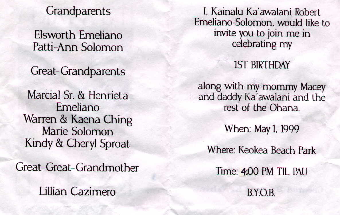
As I arrived, the pavilion was being set up for ``Kainalu Ka`awalani Robert Emiliand Solomon's'' one year old birthday party. It was a celebration with the extended ohana ('family'') that would have at least 100 guests, some coming from Oahu.

Each invitation was personalised, and inside, there was a listing of the immediate ohana.

The celebration was opened with a prayer, followed with the declaration, ``The food line is now open.'' I sat on a bench and watched, listening to the solo Hawaiian music by John Keawe - delightful. While I was sitting, James Sanchez, one of the guests, came over to talk. James was born in Kaneohe (windward Oahu), but has moved to this more bucolic part of the Islands. His father owns a banana plantation on Oahu (just over the Nuuanu Pali7 near Kaneohe), and wants him to come back and run it, but James has bought 8 acres for bananas here and is refusing to come back. His other job is small general contractor. We talked for a while before he went back to the haole (``foreigner'') part of the tables. As with everything else in Hawaii, the ``haole'' here was quite relative. Another gray bearded guest (very haole) from that table came over to tell me that the little girl in a stroller beside me, and her mother, both very Hawaiian, were his great-granddaughter and granddaughter. After a while, it was clear that the people were too busy to invite me to have dinner so I left to put up my tent.
The kids were fascinated by it. When it was on the ground, the question was ``What is it?''. When it was up ``Are you going to sleep here?''. They all wanted to see inside, and go in. A little one was inside as I was trying to stake it down. At this point, James came with a complete dinner. It was a typical Hawaiian feast - barbecued pork, Kailua pig, raw opihi and ahi (sashimi), raw salmon with peppers (I hadn't seen this before), and curry rice. He left, but came back a few minutes later with desert - equally exotic, including a coconut jelly.
After dinner the real Hawaiian Music started. John was joined by a group of three called ``Pahoa''. That lasted until 8:00pm when it was replaced by rock/disco party. John told me that they really could last the night but they needed something for the young folks. At 10:30pm, it shut down, and the pavilion was cleaned. It was quite a celebration and only missed the presence of Burt Wolfe.
There is only one other tent in the campground. They arrived back late last night, and I met them this morning. It is a family of three, Deedee (Deirdre) and Peter, both Stanford Ph.D.'s, are here with their young son, Tad. Peter and Deedee are both teaching at the University of Washington.
At about 6:30 Kainalu's family came back to finish the cleaning - it was very difficult to do a decent job in the dark.
Today I visited the Pololu Valley with Deedee, Peter, and Tad. This was a welcome rest for my bicycle muscles and the first workout of my hill climbing muscles since ski season. The Pololu Valley is at the northern end of a series of seven valleys that start with Waipi`o.
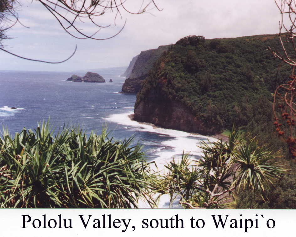
The Pololu Stream tries to flow out the northern edge of the valley. The water here is quite deep, and had a sand dam preventing it from reaching the ocean.

The back of the valley had a large, overgrown reedy flat area that must have been the taro fields when Hawaiians lived here.

The front part of the valley is pleasantly shaded with ironwoods with their needles covering the black sand. This is evidently a local playground. Tad was delighted with a large single rope swing, anchored by a concrete post and a large yellow float. There were several other, more advanced swings up the hill that Peter checked out. A sign, by an organized pile of flotsam read ``Kama`aina Playground, Michael, ???, Makai, by Karli Lawson''.

Rocks carefully delineated paths, and Tad had to be convinced that a homemade pirate sword should be left for its owner.
The next two valleys, Honokane Nui and Honokane Iki to the south are accessible by a steep narrow trail up the southern end of the valley. I went up, hoping to get a better look at the dead taro fields in the back of the valley. The trail ran, quite steeply, up a stream bed and in places showed that it had been quite muddy. Some poor horse left an 8in (20cm) deep hoof print in the mud. The only views on this trail were the sides of the trail. At about the 15min mark, the time to turn around, I was able to climb a high bank and get a glimpse of the taro fields below. They were really too overgrown to be certain but it was the only possible place.

I dropped back down the hill, and with some effort, found Tad and Peter building black castles in the sand.
We climbed up the 700'/200m(??) up the cliff back to the car and drove back to Keo-kea.

I spent a lazy afternoon in the shade, watching the kids boogy-boarding in the surf. It was a very pleasant gathering of families out for a Sunday afternoon at the ``beach''.
In addition to the large pavilion, there is a small gazebo, on a 30'/10m rock tower, overlooking the bay. It is one of the preferred gathering places on the beach. This is a very pleasant place.
We grew from two to five tents tonight. One of the new ones had another couple, Doug and Francie, from Seattle. We discussed the campgrounds, and I discovered that both campsites in the Puna district east of Hilo are ``not recommended''. Deedee said they had been told that Isaac Hale Beach Park was frequented by teenagers looking for trouble and the new couple had been warned off Mackenzie State Park. If I go to Puna, it will only be for the day.
I also learned that the lava flow that has closed the Chain of Craters road to Puna is still active. In addition, a campground shown on my map at the end of the road has been cut off by the 1993 flow. My ``new'' (1998) CAA map is evidently quite old. They also told me the road to Mauna Kea was very, very, steep and paved only to 9000'8.
This morning I checked my camping permit and discovered that I do not have permit for Spencer Beach Park for tonight. Evidently I shall not be going back there. Perhaps I will be able to make it to Waipi`o9.
As I was leaving, Doug and Francie came over and gave me their detailed map of the Hawaii. They rightly commented that it would be easier for them to replace it. I highly recommend it.
As usual, the hill out of the campground was the toughest of the day. About a mile out, I noticed a pile of fruit in front of a house with papayas at $1 each. They looked very good. I managed to excite the owner's two yappy dogs and he came out to greet me. We talked a bit about fruit, and the kind handling of papayas. I mentioned that I had lived in Hawaii Kai and had worked at the UH Manoa for three years. He said that he had graduated from UH but that the only job in Hawaii that his degree qualified him for was raising fruit. I bought the papaya and said the only thing I regretted was that I didn't have a lime. He gave me a ripe lemon - it looked like an orange. As I was leaving he said ``Hey, next time, no be stranger.''
The road to Hawi is so twisty, dropping in and out of deep river valleys that it looks quite different in both directions. At Hawi, I turned up H250, the Kohala Mountain road, to Waimea. I was warned on Saturday, of the hill right out of town. It was quite straight, and went back and forth from ``up'' and ``up-up''. It was not really that steep, but I still had trouble going fast enough to remain stable. I think I will leave the Saddle Road and Mauna Kea to the end of my trip. Perhaps I will be in good enough shape to tackle it then.
The top of the hill was the junction of the road up from Kapa`au. I must have passed the beginning of it on my way to Hawi. From this point it was a much gentler, continuous up to the crest at 3575'/768m. It was green rolling ranch land with intensely curious cows.

There was also a very strong head/crosswind. The trees indicated that this was, indeed, the normal direction. I was told by a bicyclist from Alaska, that, normally, it was raining up here. I will take the wind, rather than the rain, or, more probably, both wind and rain. When I passed the crest, it became cactus and desert, with just hints of green. At this point, on a clear (no haze) day, you could easily have seen Kona, but not today.

I stopped in Waimea at the KTA for more bananas, and came away with that and some Char-siu (deep fried fish cakes), and cucumber Kim Chee. At McDonald's, I replenished my water, had a 99 cent McChicken (surprisingly good), and a banana. When I came out, I discovered that my rear tire was flat, but not totally. After putting some air in it, I decided to continue the 20 miles to Honoka`a. Several times I had to stop to pump up the tire. The Mamalahoa Highway undulates at about 2500'/750m (the same height as Waimea) until it drops down about 1000'/300m to Honoka`a. I arrived at about 6:15pm with a dangerously soft back tire so I opted to stay at the Hotel Honoka`a Club. For $25, I got a ``hostel'' single room in the hotel basement, and I could lock my bike just outside my room.
Before supper, I took my bike out to the local 76 station to fix the flat. The people were very nice, and let me use their tire water bath to find a hole that was so tiny that the air barely leaked out. They asked, when I had finished, if I had fixed it. I told them that in a day or so I would really know.
It is now just after dawn, and I am enjoying the ferns and palms out my window. Today I will go and spend a couple of nights in Waipi`o. I will even try to be legal and get a camping permit at the Bishop Estate office in Pa`auillo, 6 miles east of here.
The road runs right by Mauna Kea - early morning, (8:00am) the mountain was crystal clear and cloudless. When I came back at about 9:30am, the top was already shrouded. In the afternoon, it is invisible. Although Mauna Kea has a peak (13,796'/4205m), it looks like a long ridge. The observatories are just stuck on one bump of that ridge which is the summit.
I found the office, right by the store in Pa`auillo, as described in my ``Rough Guide to the Big Island''. However, they no longer give out permits - the hassle was shifted to the office in Kona. I also discovered that they insisted on two weeks notice before issuing a permit. However, there is an out. Apparently the land across the Waipi`o Stream is owned by the Bishop Museum rather than the Bishop Estate and they are not at all fussy about camping. This is apparently the preferred jumping off spot for hikers climbing the ridge to Waimanu, the next valley.
I arrived back in Honoka`a at about 10:00am and stopped by the library to see if I could read my email. All the libraries are connected to the Internet but you need to have a current Hawaii Library Card and, perhaps, also be a state resident. It is possible to get a non-resident card for $25 but the librarians are unclear about the requirement of being a resident to access the Internet. To use the system, you need to establish an Internet account in your name. I will have to wait until I get to Hilo to read/send my mail.
After fixing another broken spoke (the new wheels on my new bike do not seem to be up to the strain I am giving them), and straightening the wheels twice more, I rode the 9 miles to Kukuihaele, the little town on the edge of Waipi`o. It was mostly downhill from Honoka`a - it will be a workout on the way back. I bought a bottle of wine, decanted it into one of my litre water bottles, and gave the bottle back for recycling. This is a very pleasant old plantation town, that is living on Waipi`o tourism now that sugar has left the island. Four wheel drive tours of the valley is a big item.
Your first view of the valley is from the lookout. From here it looked much like it did in 1976 when Virginia, Peggy, and I were last here. The signs say only ``4 wheel drive only''. I am about to go down on a one wheel drive, all wheel braking vehicle.
The road has not changed since 1976, except for the addition of several one-way signs and a guard rail - a reflection of the greater traffic: tour vans, pickups, and the occasional Suburban Assault Vehicle.


I have not adjusted the toe-in on the brakes very well so they were screaming. One girl, walking up, said ``Your bike sounds like I feel.'' I got down with no mishaps, and will certainly have to hitch a ride up.
My initial surprise was that the valley is over run with people, living there, who don't have any memory of the tsunami of 1946 that wiped out the valley, and the one of 1967 that added to the insult. In 1976, it was essentially empty. I stopped to comment on this fact to a 60s, hippie looking couple. Their comment was ``That's progress.'' While I was there, a young Hawaiian, driving an ATV with a trailer came by. The lady asked whether a particular friend was at the camp by the beach.
I continued down the road looking for a place to camp back in the valley. Within 20'/6m, I had to ford my first stream. I quickly decided that this was going to be a wet feet day. This was the first, of about dozen, that I had to cross. All the way, the road was lined with ``Private'' signs, and working horse ranches and taro fields. The road finally dead-ended at a small ranch. There was no place at all to camp.


On the way, I met Tom Kawai-Halanui-??? Araki, a ``native'' Hawaiian who was born in the valley. He must be one of the few that survived the 1946 tsunami still living in the valley. He agreed that it was very different back in 1976, but commented most on the increase of tourists.
Since it was clear that I was not going to find a spot to camp deep in the valley, I rode down to the beach. There are, indeed, only 4 Bishop Estate camp sites, but each one is at least 100'/30m wide - big enough for a small army of people. At the back of Campsite #1, I found the young Hawaiian, Billy, his very haole, blond wife, Laura, and their ``camp''. They live up by the falls, hopefully, above the tsunami line. Billy said his mother, who was here in 1946, refuses to spend the night in the valley, even in his hale (``house''). He loves the beach so spends much time here in the summer. The beach allows outdoor living - it is virtually mosquito free. The mosquito problem was brought home several times:
Billy, is in his early 40s, and has returned to Waipi`o after an absence of 20 years. He was brought up in the taro fields, and has come back to live and teach the art of being a taro farmer. The Univ. of Hawaii has a project to reintroduce taro to the valley. Billy is creating these new patches and guiding visiting kids who come to learn what it was like to grow taro - the sweat and the joy. Laura is originally from Washington but has been here long enough to be the grandmother to half the kids in the valley.
The beach is almost deserted. Over the weekend, though, it was apparently, a rowdy rough party.
I got up at about 3:30am to see a huge campfire down by the beach. I thought that the people may be out fishing, but I was wrong. I was visited, while writing by a 17 year old kid who said they were hanging out to catch the early morning surf.
Just after dawn, the surfers were starting to congregate. This, and evening, is best for surfing because the sun-induced on shore winds do not breakup the surf. I crossed Waipi`o Stream, after watching an old hand come back from the other side, and walked up the Bishop Museum side of the beach.

The stream is about thigh deep, and is capable of toppling even local experts. The valley and ridges are beautiful at all times but stunning in the early morning light. Except for an early morning jogger who passed me, the black sand beach is untracked. Well almost untracked. It is covered with huge (2in/10cm) sand crab holes, and there was a long track of mongoose footprints that stopped at every hole. There was no indication that he was successful. At one hole, I saw a blur of a crab returning to safety.

At the end of the beach there was a small shrine on a palm to ``Roland Schneider (1961-1991)'' (strange spelling). Laura told me that he was a New Zealander who drowned and was dismembered by sharks. When I returned from my walk, there were about 13 surfing cars line up on the beach. One belonged to Susan and her two dogs, who I originally met in the Pololu valley. I excited her dogs while I was there because of my dayglow green/red uniform. Here I was much more subdued. Susan was born in Kahala on Oahu. Her house was one of the original plantation houses, and is probably ready to be condemned. She lives now in Waikoloa, but her brother is living in a tent inside the Kohala house until the Bishop Estate lease runs out. They can't afford the $1,000,000 that is being asked.
My major enterprise for the day is to get more water. The litre that I had when I came to the beach is almost all gone. Billy, and Tom, told me about some springs up the mountain. However, getting water turned out to be easier than I thought. On the way out I met Laura. She directed me to one of her grandchildren's houses and told me to say that ``Laura sent me.'' Junior, a big Hawaiian, his dogs, and a small boy, who normally goes to school in Hilo (Junior was giving him a week off in Waipi`o because he was named the best student in his class), were there, just as Laura had said. The spring ran directly into the river and I waded in to fill my three, one litre bottles, and the 3 litre wine bag that becomes my extra water bag after the wine is gone.
Junior told me that the reason that the valley seemed so different now, than in 1976, was that it had really changed. The road originally ran in front of his house, and across a bridge. The road and bridge no longer exist. His house did not exist then, either. The current road goes around the outside of the newly fenced off areas. He was especially sad about the two huge waterfalls at the left end of the valley. They were both dry. Although sugar has left Hawaii, the new golf courses seem to have an insatiable demand for water. The falls used to be torrents all year round. Now they flow only after heavy rains10.
I arrived back at about mid-morning, read some more from my ``Rough Guide'' and made lunch. I think that I have seen about as much of the valley as I can from the road. Laura and Billy have four kayaks that are used for many things, including tending of a long line (fishing) that they have off shore. I suggested to Laura that, considering the current difficulty for strangers to get around the valley, that kayaking up the Waipi`o River would be a great way.
I borrowed a kayak and started up river. Both ridges defining each side of the valley, especially the one down from Kukuihaele, were almost intimate. It was a quiet easy paddle, up river with the wind. I shared the river with families of ducks, some red faced geese, and the long beaked Black-crowned Night Herons - Billy called them `Auku`u and characterized them as ``mighty hunters''. They were especially fearless. Several times, I drifted by one on a branch 6'/2m away, and it stayed put, and just stared. The geese were less sanguine. The horses grazing on the banks also ignored me. I finally quit when the river seemed to be almost dammed. I had hauled the kayak through several fast shallows before that and decided it was time. The upper end appeared to be at about the same place that the road ended yesterday.
Going downstream was especially easy and relaxing. A couple of times I had to get out to bypass some rapids. On the way up, near Junior's house, I noticed a small stream going off to the left. This was very narrow, and really quite intimate - a delightfully tight paddle. Again, I quit when the stream disappeared into a taro patch. I turned around, and drifted back until the onshore wind forced me to paddle.
When I got back, Billy had returned. I told him that I didn't think that kayak tours of the Waipi`o River were quite ready for the general public. He had no intention of indulging in such anti-social behaviour. It was, though, a very different, and relaxing way to feel the valley.
It is almost dawn. The surfers that came for the evening sets stayed all night to indulge in the morning sets.

Today I leave, as Laura said, ``our beautiful valley''. I am aiming for Kalopa State Park, on the slopes of Mauna Kea, just on the other side of Honoka`a.
I said goodbye to Billy, Laura, and the rest of their family and arrived at 7:30am at the junction to wait for a ride to the top of the hill.

I was there for just over an hour - only one feasible ride actually passed me without picking me up. The others were too small11 or too full. Finally, Maka`ala stopped her small pickup. I had to totally unload the bike to get it in. While I was in progress, Laura passed by in one of their trucks heading inland. Maka`ala was on her way to Honoka`a - perfect for me. She is another refugee from Oahu who has taken up a new life on the big island. In all fairness, though, she has roots here. She owns the Pu`uo-lani Ranch on the Kohala Mountain Road. I stopped at their front gate to refuel, and a blond lady, driving in, asked me if I needed anything. Maka`ala said ``That must have been Christine.''
Maka`ala let me out just after 9:00am - sooner than if I had gotten an earlier ride to the top of the Waipi`o hill. I went shopping again at Tanaka's Supermarket and indulged in some delicacies - Maui Style Chips (made by Frito-Lay in Aiea, Oahu), ahi sashimi marinated in soy sauce, some Japanese seaweed soup, and some arare. Lunch will be a little different today.
Kalopa was only about 6 miles away, but the last 3 were all up hill, to 2100'/640m. I was offered a ride, about halfway up, but decided to struggle up. Later, I wondered if I had made a mistake.
As I entered the park, the custodians told me that they had just locked up the campground because they had been painting new parking lot lines. They also asked me if I had a permit. Of course I did not. ``No permit - no camping!''12 However, he was willing to check if a place was available and write me up a permit on the spot. There was a place.
The campground has only three sites. They are all roofed shelters with concrete floors. With no ground cloth and rain fly, my tent was up almost instantaneously. The entire area is grass, surrounded by tall eucalyptus trees - quite protected. The shower has power so I am able to recharge SAM's batteries. I discovered, last night in Waipi`o that my second battery would not hold a charge - it was quite dead after being unused for a week, and would not recharge.
The shower was, as I was warned, quite cold. The outdoor showers in the beach parks are quite sun-warmed. It has been a week on the road and I need to wash clothes. The cold water and no plug dissuaded me after I doused my shirts and a pair of socks.
I am all alone. It has been a quiet and an uneventful night. Yesterday the Kalopa custodian told me of a county park at Laupahoehoe, about 15 miles from here that allows camping. It is not on any of my maps nor is it listed in the Rough Guide. It even has drinking water. If I had known about it yesterday, I probably would not be here.
I will see if I can follow some of the small roads on my map to get to Laupahoehoe. Nobody I talked to seemed to know, for certain, whether they are private. In the past, private cane roads were passable. but now that this is cattle country, the roads are quite well gated. All these gates have the sign ``No Trespassing, Hunting, Fishing - $1000 Reward for information leading to the conviction of anyone stealing cattle.'' I don't suppose I am a threat for the latter on my bike, but even so, I will not go around the gates.
The roads were very private. The first one shown on my map went into the front gate of a ranch. I stayed on H19 (the ``Belt Road'') all the way to Hilo.
The defining character of the Hamakua Coast is 500'+/150m+ cliffs cut by deep river valleys (here called ``gulches''). They are cut by runoff from Mauna Kea and Mauna Loa. The northern gulches were dry, but by the time I got to the North Hilo District line, there was water. In all cases, there was lush vegetation. In the northern gulches, there were also houses, all looking very ``up country''.

The highlight of the day was Laupahoehoe Point. This is the site of an old lava flow, down the Laupahoehoe Gulch, that left a lava point at the sea. The road down was a delight. It was narrow, winding, hanging on the side of the cliff, but with ironwoods and eucalyptus on both sides. Occasionally you would see the high cliffs up or down the coast, outlined by a brilliant blue Pacific.

It was when I saw the southern cliffs that I realised I had misread my map. I thought that there was a road running along the ocean to Laupahoehoe Town from the point. When I looked again, more carefully, there indeed was a tiny break in the road just south of the point. I was going to have to ride back up the same way.
The lava as it hit the ocean created a congregation of high pillars. These were being washed by white foam from the breakers crashing in. The county park took up the entire point. It looked like a very good place to camp, and even has water. At 10:30am, though, I was not about to stop. Just mauka of the point is a small community of houses. There was, of course, no store or other services.

I hesitated, gaining my courage, at the bottom before tackling the road up. Much to my surprise, it was much less steep than I had thought coming down. The road was even a delight going up.

From there to Hilo, it was up and down - the major downs into ``Scenic Valleys''. These were wide gulches where the road dropped far enough to make a bridge economically feasible.

The plateau was, until 1994, continuous sugar plantation. All that remains of the sugar are remnants by the side of the road. The conspicuous new crop is papaya - grove after grove, but still leaving much room for something else. There were also plantings of new trees. They could be Macadamia Nuts, but I don't really know what a Macadamia tree looks like, especially young ones14.
I worked very hard to arrive in Hilo before the county offices closed at 4:30pm. After wandering around Hilo for about a half hour, I finally found them, only to discover that my maps were wrong - there is no camping in Hilo. James Kealoha Beach Park, which was on the permit list I got in Waimea, had, according to the office here, not allowed camping for years. The nearest county park with camping was Kolekole, 15 miles up the coast. I had already passed it, sitting at the bottom of a flat gulch, with its own river, no drinking water, and a tsunami warning siren at the bridge. I was not about to go back. The recommended place to stay in Hilo is Arnott's Lodge. I reread the section in the Rough Guide, and discovered, that they allowed camping in their grounds. That is where I am now.
They also have Internet access, and laundry facilities. It was nice to wash a weeks worth of clothes - everything but my bedtime stuff - from the convenience of my tent. Camping costs $9/night - less than KOA on the mainland.
The first order of business is to get a new tire for my bike. The other two requirements were satisfied last night. Then I shall wander around Hilo.
Hilo lived up to its reputation of the ``rainiest city in the USA''. It was almost continuous localized drizzle, intermixed with the occasional deluge. The first one caught me under a tent at Borders ``Annual Book Clearance Sale''. This sale was very tempting. I wished that I had had a stronger powered vehicle.
The highlight of the day was the Saturday Mamo St. Farmer's Market. Those papaya groves are having an impact on the local market. Papayas were going for as low as 7/$1. They were a smaller variety but still a lot for the money. Normal sized papayas were selling at 4/$1. There were bags of tomatoes, Maui onions, and all manner of exotic chinese vegetables, all for $1 a bag/bunch. The bags were all too large.

I also got a lesson in the origins of coffee on the Big island from Rufus Daigle, who has a plantation in Kurtistown, just south of Hilo on the way to Volcanoes. He claimed that coffee on Hawaii originated on the slopes around Hilo. He has only a few acres, but is planning to buy eight more. His coffee comes with ``poetry'' - some of it quite racy. While I was there, a local teenage girl came by, and asked where the coffee was grown. She didn't know that coffee was grown on this side of the island either - and she lived here!. Rufus said he was selling here, rather than Kona, because there was less competition, and he sold out his entire crop this way. He also said some of the Kona producers got busted last February for using Brazilian coffee rather than Kona in their coffees. Most ``Kona Coffee'' sold is only 10% genuine Kona Coffee.
The crisis of the day was the discovery, at 4:00pm, of a bent axle on my rear wheel. This was quite distressing as the wheels are new and I had been only riding on it, with load, for about a week. This is also a precursor to a broken axle. At 4:30pm, I was able to start out looking for a bike store, with directions from the people at Arnott's. The one they directed me to, by the Mamo Farmer's Market was closed. People in the neighbourhood felt that it was the only bike store in town. I was directed to a Kayak store for information, possibly run by the same guy as ran the bike shop, but it was also closed. A kid at the next Shell station said there was a ``Mid-Pacific Wheels'', two stoplights down, and up the hill. It was a long way up the hill and I wondered whether I was really going the right direction. Just as I was about to give up, I found it - open. I bought a new axle for $10, and, after they had examined the strange folding ways of my bike, left to go back to Arnott's to put it in. While doing that, I also discovered another broken spoke.
I didn't get finished before the night rains came so I will continue in the morning.
After finishing my bike, I will take a day trip down to Puna. This area has been continuously devastated by lava flows. The normal tourist destination in Puna is Kalapana, a village that was wiped out by a huge flow in 1993. The same flow also closed the road that connects Puna with Volcanoes National Park. It is a large 10 mile wide lava flow with Kalapana buried somewhere in the middle. I arrived at about 3:00pm and just explored the outer fringes. Hilo was 40m/60km away and I was worried about arriving back before dark.
The road along the coast from Kalapana (H137) is a delight. It starts out through relatively recent lava flows with rocks covered by grey/green lichen and ohia/lehua trees scattered around. Then it suddenly becomes narrow, rough, and winding - through real jungle. The sea is largely invisible and the cliffs are only about 10'/20'(3m/6m). high. The ocean is extremely rough with an immediate shore of sharp jagged lava spikes - it is quite beautiful, but all you really can do with the ocean here, is admire it, or fish. The water appears to be largely inaccessible. The road is canopied by huge trees, possibly koa, which means both coolness and relief from the sun. Now it is sparsely inhabited, but that appears to be changing. Along with the huge ferns, vines, koas. banyans, there was the occasional orchid - just beautiful.


``Pahoa Village'' is the small town at the tip of the triangle that now defines coastal Puna. When I arrived at noon, the village market was in full swing. The people, and the town, would have fit right into the early sixties. It showed an artsy decrepitness that was almost quaint. It even had a Thai Restaurant. I was tempted to stop for lunch, but there was no posted menu, and there was a sign that they took Visa, MasterCard, and American Express.


Just before dark, I left Pahoa for Hilo. I had not noticed coming, that the road from Pahoa to Kea`au, was mostly downhill. After 6 miles of ``no shoulder'' out of Pahoa, the shoulder became almost a full lane wide, all the way to Kea`au and on to Hilo. This was perfect, because it was getting quite dark when I hit that section. In fact, I didn't stop at Lava Tree State Park because I wanted to get to the wide shoulder section before it became too dark. I rode the last hour+ in complete darkness and arrived back at Arnott's at just about 8:00pm.
Yesterday, I discovered, at the end of the road above Kalapana, that I had bent my brand new axle - it had lasted a whole 30 miles (50km), and I was not even heavily loaded. This morning I will put the old, less bent one, back on. I will keep the new bent one for a real emergency - a broken rear axle.
I had two reports, both from bicyclists, about the Volcano road - both wrong. One said it was gradual and easy, the other said it was a continuous 7% grade. It was gradual, but unrelentingly up and not really easy. One nice feature of the road were the altitude signs every 500'/150m. I looked forward to each of them as a token of accomplishment. The road crests at 4023'/1230m. Including the few hills, it was probably a 5000'/1500m climb. The sun for the first 1500'/450m sapped my strength and spirit. The clouds, and even the rain was a welcome relief.
The ``New Volcano Road'' has a lane wide shoulder for most of its length - an excellent bicycling road. The rain belt forest was tree ferns, koas, kukuis, bamboo, and 100'+/30m+ eucalyptus. As soon as the rain stopped, the road was dry, and there were only clouds, the forest became scrubby ohia-lehua trees.
There is much new, and some old, invisible housing along the road. It appears to be concentrated on the ``Old Volcano Road''. This road, unfortunately, suffers from unannounced, abrupt, dead ends so it is not reasonable to ride it. A very pretty section of the road is through Volcano Village. It is shaded by a variety of trees, and lined with B&Bs. Most importantly it has a grocery store and even an Internet Cafe.
The NPS campground, Namakani Paio, is on the Kona side of the crest, about 5 miles from Volcano Village. It is a beautiful site set under a eucalyptus grove. It has almost no mosquitoes, and is free. Its only drawback is that there is no power or showers.
When I arrived, I was greeted by Roland, a Swiss-German who had been camping with me at Arnott's. His life runs in two year cycles. For 18 months he goes around the world, the for 3 months or so, he goes back to work in Switzerland, as a machinist and maintainer of heavy equipment, to finance his next trip. He has ridden his bicycle around the world several times, and finally put it away for good, after a night sleeping by the road, inhaling truck fumes, by a restaurant in Darjeeling. Now he walks, and uses any other transit he can find. As far as I can tell, he has walked every major trail in the USA - Pacific Crest, Appalachian, John Muir - he even skied three days on the Muir Trail ending in Tuolumne Meadows. Last night he took the Arnott's Lava trip, and they dropped him off at the campground.

Today I pushed my bike over the trail leading to the Jagger Museum and Geological Survey Center - both on the Carter Rim road. I arrived just as it was opening. The poor girl on the desk became so frustrated at my questions that she phoned for a geologist to come over and talk to me. As I expected, the mechanics, and especially the stability of the hot spot was still unknown. One interesting fact was that there was a trace of the Hawaiian Islands to where they end at Kuré, and then as underwater seamounts right off the Pacific Plate. The line ends at the Aleutians in Alaska. There has been an abrupt turn in the direction of movement of the Pacific plate from north to west several hundred million years ago.

The rest of the day was spent hiking down from the visitor center, across the floor of Kilauea to the Halema`uma`u Caldera (fire pit). It was in 1967 that I saw this caldera active with 60'+/20m+ fountains of lava - quite a change today. I followed the Halema`uma`u trail to the caldera, across the floor. I do not have the words to describe the chaos in the lava surface - nor the inspiration caused by the growth of ferns and ohia-lehua trees, sprinkled in the cracks. I really don't know how a small plant manages to get started in rock with no organic content. The rocks on the edges of the caldera are heavily cracked, and obviously unstable. I gently pushed a small piece into the crater to confirm this. A most surprising thing was three tropicbirds circling around in the crater - why?
On the way back, I followed the Byron Ledge Trail. It ran across the Kilauea floor until it hit a high ridge (ledge) that separates Kilauea and Kileaua Iki calderas. It climbs sharply up to the top of the ledge, several hundred feet, and runs through a nicely shaded ohia-lehua forest. This was a bird-song filled walk, with a Kalij Pheasant, quietly foraging, and largely ignoring me by the side of the trail. It was a welcome relief from the starkness of the Kileaua floor. At the end of the ridge, it dropped back to the floor, for the 500'/150m climb back up the Halema`uma`u trail to the Volcano House and Visitor center.

I continued around the Crater Rim Road, stopping at several small caldera, Kileaua Iki, Pu`u-Pueo?, ..., and finally the overlook for Halema`uma`u. There was a massive flow in 1974 on this rift zone, and the road has been relocated so it is easy for everyone to get to the edge of Halema`uma`u - on the other side of the caldera where I was this morning. This is prime Nene (Hawaiian Goose - the state bird) territory - with many signs slowing the traffic to 25mph. The trail to the calderas had its own Nene - properly banded because the Nene is an endangered species. It was a delight.

Today I went down to the end of the Chain of Craters road to see if I could find the active flow in the park. This flow started in 1983, has been responsible for closing a 10mile/16km stretch of the road to Puna.
I left at about 7:30am, pushed my bike over the hill to the Jagger Museum, and started down Crater Rim Drive. It was cool, cloudy, and misty, and very quiet - no cars was a delight. I was going slowly enough, and in the right direction, to notice the sharp ``V'' in the earth that was the ``Southwest Rift'' and a sign ``Don't pick the berries - the Nene need them.''
Each crater on the Chain of Craters road is quite different, and considerably older than the ones around Kileaua, except possibly Lua Manu (``Manu's Toilet'') right near the start of the road. Ko`oku Olau was totally overgrown and filled in with trees, Puhimau's caldera was mostly filled by a huge rock slide, and Pauahi's caldera was a complete circle and a semi-circle. Mauna Ulu is a new mountain formed from flows starting in 1973. These flows, and later ones in the 80s and 90s buried the road, in places, with 100m of lava. The most impressive part of the road was the descent down the 2000'/600m Hinole Pali. This was quite steep - ``Busses check brakes!'' - and showed the remains of lava spills over the sides. The coast below it is a wide flat plain, that held many Hawaiian villages in the when the Europeans first came. In 1975, during an earthquake that accompanied a flow, the coast line dropped 2.5m.

The first sight of the current flow is a huge plume of steam coming out of the ocean.

The entry point is about 3.5miles/5km from the end of the road, over smooth, but extremely rough, pahoehoe lava. The signs warn of fumes from the entry containing hydrochloric acid and volcanic glass15. On top of that, the steam, obscures the flow. Arnott's go inland to find some small holes in the tubes that currently cover the flow. It is possible to trace the flow from the top of the pali down to the sea by the whiffs of steam rising and the overhead helicopters. I opted to go inland on the first marked trail that I saw. This was very rough, and climbed a short section of the pali. This climb was too dangerous for general tours so I felt that maybe I was going the wrong way. Just above the pali, I saw a sign Kalapana Trail sign. I continued up until I realised that the trail was going the wrong direction. Then I cut straight across the slope to the section that had the pahoehoe flow.


The pahoehoe lava was easy to cross compared to a short section of greenery (burrs, thorns, and small sharp branches) and the a`a lava. A`a lava is a pile of razor sharp chunks, quite unstable, and prone to sliding from underfoot. If you fall, you will cut your hands to shreds on the lava. I wore my leather work gloves so my slips were manageable. I protected my legs in the greenery by rolling up my dayglow green leggings.
The actual flow is underground in lava tubes. The wisps of steam mark the basic passage of the flow. Then I noticed that there was a spot where the light was wavy - a sure sign of heat. This was, indeed, a spot where the lava was quite near the surface. I found an open wall, about with a solid red glow.

Then I found a real hole, about 1m in diameter, where I could look down, 10'/3m onto a red river, about 10'/3m across. However, I was not sure what I was looking at - nothing seemed to be flowing. I threw down some lava rocks to see if they would splash, but instead they bounced. What I was seeing was the current solid top of a new lava tube covering a deeper underground flow.

My wanderings had taken me, unfortunately, to the far side of the flow, and I had to cross over to get back. At one point, I decided, it would be prudent to cross before I got too close to the water entry. I estimated that I was probably 1km? away. I started across, and the pahoehoe was getting noticeably warmer. I looked down into some of the cracks and the glow of red hot lava 2'/60cm below. I carefully avoided any section that looked like a roof of a lava tube and continued across. Finally, 50m-100m? later, I got to some noticeably older pahoehoe lava and decided that I was across. Then I looked to the ocean and noticed a huge light aberration, with no obvious localization. I went closer to look and discovered a new pahoehoe surface flow. There were red fingers oozing out in all directions.

I tried to capture a piece of the new flow on a chunk of lava but the lava broke in the few seconds I could stay there. The growth was slow, but still much faster than I had seen with the a`a lava on Mount Etna in Italy. I went around the edge of the flow, over 100m, stopping several times to watch. On one of them, the ropy pahoehoe formed behind a dislodged chunk before my eyes.
After almost 6 hours of hiking, I arrived back at the end of the road, passing over several ``islands'' of road, following a considerably easier pahoehoe route.

It was about 5:00pm so I had to find a ride back up the hill. After several misses, I heard Mike Wampler, musing out loud as to whether my bike would fit in his Subaru Wagon. I assured him it would, after I folded it up. Mike and Cindy are from San Jose where Mike runs a ski rental shop. They were staying in Kona, so I got a ride right back to my tent.
It was a successful day.
This morning I ventured down to the washroom by the cabins to see if it had power so I could recharge SAM. When I got there, Kalihi Ching, from Kaimuki was inside. I asked through the window if there were power. He found the outlet and let me in. We talked about the island, and especially Waipi`o. He said it was ``calling him''. I told him about my experiences, Billy, and Laura. He was excited about going to see, and sad there was no water in the falls.
Today was a lazy day, doing some washing - using my waterproof fold-bag as a washing machine - getting supplies at Volcano, and visiting Kipuku Puaulu, the ``Bird Park''. This is an island of forest that has been spared the ravages of lava flows of the past 1000 years. The koas and, most surprisingly, the ohia-lehua trees were over 100'/30m high, and one ``giant'' koa had a 6'/2m trunk. Kipuku Puaulu is about 1.5m/2km up the Mauna Loa road. The top of the Mauna Loa road here is only 6000' (8000' below the summit) and 2000'/600m higher than the Bird Park. However at this point it appeared to be diving down into valley. The total bike climb to the end was not at all obvious.
Kipuka Puaulu's loop trail climbs slowly through mixed forest, mostly ohia-lehua, until it reaches a mostly koa forest with the ``giant'' koa. The bird songs were continuous but I was unable ever to locate a bird from listening to its song. The others I saw flitted by and disappeared before I could focus my binoculars. The only stationary birds that I saw were a Kalij Pheasant and a House Finch. The more exotic native birds just flew by quickly flashing a blur of colour. It was, though, a delightful, cool, shaded and leisurely walk - a marked contrast to yesterday.
Today was unusual in another way - the sun was out all day.
Today I leave Volcanoes for the Ka`u. This ``Ka`u desert'', just south of Kileaua, gets as much rain as the rest of this end of the island, but it is mixed with the volcanic fumes to give ``sulphuric acid rain'' a whole new meaning to ``acid rain''. The road actually skirts west of the desert so all you see is its outer edge, semi-naked ohia-lehua trees in a 400 year old a`a flow.
It was downhill for about 22m/35km, through successively improving ranch land, to Punalu`u. This is the best black sand beach on the island, now that Kalapana has been destroyed. Black sand is volcanic glass, made when the lava, of a specific temperature and composition, hits the ocean. Pure black is quite rare, but the a`a ground version is quite common. I arrived there very early - 12:00pm, and cooked myself some lunch, much to the interest of an ``Elder Hostel'' tour being run by the Lyman Museum in Hilo. I had intended to stay, but it was too early to meditate for the afternoon on black grains of sand.


The road bottoms out at Punalu`u so it was uphill to Na`alehu, and up to the beginning of the South Point road, climbing over the tip of Mauna Loa.


I was resting/refueling in Wai`ohinu, home of the long dead ``Mark Twain Monkey Pod Tree'', when a lady, riding her bike up the hill stopped to chat. I told her of my need to find a place to camp, so she told me of ``Margo's Corners'', a small place that catered to bicycle campers and only required a small, voluntary donation. I was to follow Kama`oa to Wakea, and then down Wakea. Margo's Corners turned out to be inside a new housing development, Discovery Harbor. I followed the lady's directions, but hit the end of the development and the end of Wakea Rd. and missed Margo's. Here there were many short, vacant, dead end streets, lined with bushes. Finally I found one that was a candidate for camping - secluded, not visible from the road. After not being able to get my ground cloth to compress the foot high grass, I decided to look some more. It was pure uphill from here, but just as I started, I met an old couple, walking their dog, who said, ``You must be looking for Margo's.'' With their directions, I found the place, only to discover that it had gone considerably more commercial than the first lady had reported. Margo now charged, $25/night including supper and breakfast. She also did not allow any cooking in her backyard. This meant that I couldn't make my early morning coffee. I said no thanks, went up the hill, and turned east on Kilokea?, the main street of Discovery Harbor. It promptly dead ended, with another going mauka, towards Kama`oa Rd. Discovery Harbor is built around a golf course, that, incidentally, needs better grass and more water, with most of its holes separated by different streets. I guess the idea was to give lot of people houses that were on a street and the fairways. In a lot of places, the course got so close to the road that there was no room for a house. I found a path, leading through the woods to a fairway, with a widening in the middle, that was big enough, after I had relocated some cut branches, for my tent. It was not easily visible from either the road or course.
It was near sunset when I stopped, and dark when the tent was completely setup. I washed with my ``no rinse'' soap - you just wash, and towel dry and clean, rubbing off the dirt. After a supper of ready-cooked spicy Portuguese sausage, I went to bed.
I will break camp as quickly as possible, and head for South Point. South Point is the landfall of the original Hawaiians, discounting the existence of an earlier race of Menehunes, and the farthest point south in the USA. It was my original destination yesterday before I was diverted to Discovery Harbor.
The road to South Point is a single lane, 2.5m wide, paved road with quite rough surface. In occasional places it is a full two lanes. The reason for this is not at all obvious from the geography of the road. South Point is a wide, very flat, point, just north of the first pali of Mauna Loa. It does not have any real physical charm, so I quit about 1.5m/2km above it, about half way down from the Kamoa Wind Farm. This ``farm'' is an establishment of about 36 Mitsubishi windmills for generating electricity. Less than half of them were running. There did not seem to be any easy way to service them, unless there was an internal elevator, but I didn't see any doors at the bottom. Apparently the variability of the winds was too much for them. They also seemed considerably smaller than the ones I saw in Denmark.


The whole peninsula was ranch land - several ranches were for sale, although it was hard to see how you could earn a living on a ``23 acre working ranch'' that was for sale.
The road back climbed up the pali to 2000'/600m. It was not that steep, but unrelenting climbs drain the legs, even early in the morning. It took me 30 minutes to get to the end of South Point, and 2 hours to get back up to the junction. From there, the H11, Belt Road, stayed on the high ground all day. It started at about 2000'/600m, dropped to 1700'/500', back up to 2000', and then down to 1500'/450m. It then oscillated between 1500'/450m and 1000'/300m all day. Nothing really unrelenting, but I am sure that I accumulated at least 4000'/1200m in climb during the day.
Initially, the road ran through scrubby pasture land with views down to South Point. Then it hit the 100 year old a`a lava flows that are being sold as new housing developments in ``paradise''. The first of these was ``Hawaiian Ocean View Estates'' (HOV) that began in the late 50s. Apparently, when some of the buyers saw their plot, they almost had heart attacks. After forty years, there is still very little to show. Along with the a`a lava, on which it takes, under the best of conditions, a very long time for anything to grow, there is no water. This side of Kona has a thriving business selling water catchments. The rain gutters on your house funnel the water into big holding tanks.

The current reality in HOV is
After the recent a`a lava flows came MacFarms Macadamia Nut Farm, still at about 2000'/600m. This was the beginning of the ``pick up the fruit from the side of the road day''. It started with macadamia nuts along the roadside. In Australia, they sold a lot of their macadamia nuts raw. Here I tried some - they are really quite good. Later, I found the first, of a large number of ``public property'' papaya trees. The one of interest was sufficiently near a high bank that I could pick an almost perfect one. Later, I saw several more on the ground. These were ripe, but managed to survive the fall unsmushed. I have never seen this before on any island. Then came the avocados. They were littering the side of the road from huge avocado trees. The real skill was deciding which was ripe enough to eat immediately, but still had not been attacked by ants. I decided on one - it was quite good, as were the papayas - I had them for supper.
Just beyond the new ``Kona Paradise Estates'', the road narrowed, and became much pleasanter - shaded and wooded.

It was mixed, 100'+/30m+ ohia-lehua trees, koa, breadfruit, and .... There was the occasional drizzle - very nice riding. I intended to spend the night at Ho`okena Beach Park. I had been warned that it was a very steep road - it starts at about 1000'/300m, and indeed is very very steep for the first 200m. I had just ridden down this initial spot when I was passed by a pickup full of teenagers on their way down to the beach to have some Saturday night fun. As they went by, one harassed me out the back of the truck, waving a rope, and laughing. I decided, that, along with not having a permit, that this was probably not a good night to camp at Ho`okena. With some effort, and a short push, I made it back up to the highway (H11 - Belt Road) and continued up to Captain Cook (1500'/450m). The Manago Hotel in Captain Cook, is one of the oldest hotels on the island, and has inexpensive ($25 single, $28 double) in their older part. I didn't know the exact price, but the Rough Guide said they had rooms under $30. Right behind me, checking in, was a couple, temporarily living, in Montréal.
I had a shower - first one in several days - had supper, and went to bed. I will stay here two nights.
Today I took a 20mile/32km circle tour down (1500'/450m) to Kealakekua Bay, where Captain Cook was killed, and Pu`uhonua`o Honaunau National Historical Park also known as the ``City of Refuge''. On the way back, I stopped at several of the Kona Coffee Museum/Stores that were closed when I arrived yesterday. It was an empty bike tour - only tools, water, bananas, and trail mix - much easier than a full bike, but the 2000'/600m total climb for the day was still noticeable.
Before I left, I stopped at ``Island Fresh Banana Bread'', the home of ``Auntie Helen's Banana Bread''. Auntie Helen appears to be a big haole guy, who was very proud of his high banana count bread. We talked of my trip, the changes in Waipi`o, and his lock on the banana bread market on the island. I left with two bargain (day old) Banana Macadamia Nut Breads.
I started down Napo`opo`o Drive, through a delightful, flowery middle class pali neighbourhood, with expanding views of Kealakekua Bay. Near the bottom I stopped at a new Kona Coffee Factory Store/Museum and tried some mediocre French-Vanilla Kona Coffee.

When I arrived at Napo`opo`o, with its Hikiau Heiau, on the southern side of Kealakekua Bay, I was greeted by a gathering Hawaiians, who were looking on in dismay, at one of their drunken comrades in the middle of a swearing tirade. I locked up my bike, and looked at the 3' to 4' surf - a rough day for snorkeling. After some indecision, I decide the situation was too tense so I started to leave. After about 10m, I heard a huge hiss and my back tire went flat - slashed by a piece of glass. This was relatively easy to fix. I was able to locate the slash, and fix it without removing the wheel. It's amazing how a little mishap like this will attract the bike riding kids. They were very curious to know exactly what had happened, how I fixed it, and then, after 10 minutes of snorkeling - the fish on the coral were plentiful, but I was being thrown around by the surf - the kids accompanied me to the edge of their village of Napo`opo`o.


The road out of town was through old Hawaii - beautiful and tropical. Then I crossed 4 miles of the flat ``green'' lava bench that makes up the coast below the pali.
The ``City of Refuge'' is probably the most important historical site in the state. It was where offenders could go to be absolved of their crimes. The crimes (breaking of a kapu (``something forbidden'')) were very easy to acquire. All it took was your shadow in the wrong place. The penalty for breaking any kapu was always death.

The road up from the City of Refuge, H160, was much gentler than the one I took down, brand new, and lined with planted brilliant Bougainville. It also joined the Belt Road (H11) at slightly under 1000'/300m. The next 500'/150m was the climb on H11 that I did yesterday.

This part of the road is where I stopped to taste some more Kona coffee. The first one made theirs too weak, and may not have been 100% Kona. The second, Royal Kona, had a wide variety of designer coffees and some pure Kona. Theirs was quite good, but still not worth $20/lb. The decaf version was a bland Kona blend - not very exciting.
Today is the end of my ``Tour de l'Isle''. Kailua/Kona is about 12 miles down the hill. I am going to turn around and go back to Hilo, to use as a base for an assault on Mauna Kea. My experience yesterday showed me that I will need to find a ride to the top of the mountain. Without a van-assist, and the ability to stop any where at night, I don't think I can ride it.
I stopped at an ``avocado drop'' spot and picked up two, ``perfect to eat today'' avocados. When you change directions on a ride, you see the world differently. In the counter-clockwise direction, you are on the edge looking down the pali - it opens up as you ride. However, you don't get to see down all the time. Except in the open lava flows, the trees are high on both sides.
Until HOV, ``The world's largest subdivision.'', it was a delightful mix of large trees, ferns, and bird songs, and birds, including a mother turkey with two babies - this was really a turkey. At HOV, it became several miles of brown a`a lava. In addition, I hit a really strong head wind. It had been calm to that point.
Just after I passed South Point Rd., I started down a very steep 2 mile hill, all the way into Wai`ohinu. The lady who redirected me to ``Margo's Corners'' in Wai`ohinu, had said to me ``You don't want to go up the hill at this time of day.'' I now know what she had meant. There may have been some trial with Margo, but it was nothing compared to the damage that hill would have done.
Na`alehu is at the top of the hill leading down to Punalu`u. At the bottom, the rear tire felt distressingly soft - ugh, again. Pumping did no good, so I turned the bike upside down and found new glass cut. I fixed it and pumped and pumped, but could not get it above 30lbs. At that point, Tom and Jason, two serious mountain bikers on their way home, near South Point Road, turned around and asked if I needed help. I used their pump, increased the pressure to about 40lbs, and heard a pop and hiss - something had definitely popped. They stuffed my bike, gear, and me hunched over it into the back of their station wagon and drove me the eight miles to Punalu`u.
At 11:30pm I was visited by four HPD policemen checking camping permits. I, of course, did not have one. However, they were not, unlike the parks department enforcer at Spencer Beach, interested in casual campers. They were looking for repeat, unpermitted, offenders. There are two pavilions at Punalu`u, one of which allows camping, if you have a permit. That pavilion was being used tonight by a middle aged Hawaiian, complete with his radio, huge complement of food, and a gathering of friends earlier in the evening. I suspect the police discovered this, and came down, in force, to check.
Tom and Jason said that they would be back at 7:00am, on their way to a day at Volcano, to check to see if I had been able to fix my tire. I was hoping to convince them to drive me up the 4000'/1200m hill so that I could get to Hilo today. I packed and folded my bike. By 7:30am, they had not shown, but my neighbouring campers, the only others tenting, were just getting up. Martin and Corinne, from Munich, were now on their second last day on the island and were planning to drive to Kapa`au, about 10 miles from Hilo. Martin was very skeptical that all my gear, theirs, and their two suits that had to remain clean and unwrinkled would fit in their rented Corolla. They totally cleaned out their trunk, and I was able to fit in everything, except the front wheel. Much to my surprise, their stuff took only half of the back seat.
They enjoyed camping because of the freedom and price, so I told them about Arnott's, their camping policy, and asked if they would drive me there. We arrived at Arnott's at about 9:30am. I unloaded the trunk, and they checked out Arnott's hotel rooms. They decided they were not nice enough for the asking $43/day, and left.
I spent most of the day looking for a new wheel and tire. When I was trying, and failing, to put the new tire on my old rim at a gas station, Martin drove in, around the pumps, and by me, without stopping to wave ``hello''.
After visiting all four bicycle stores in town, I discovered there was only one wheel in Hilo that would fit my bike, and the Pacific Wheels store owner did not recommend it because of the weight I was carrying. By this time, my rear wheel had spontaneously become a pretzel, so I had no choice. It, and some new brake pads, are now on my bike.
Arnott's tour to the top of Mauna Kea was leaving just as I arrived. They have another one leaving Friday so I am negotiating a ride up, with my bike, and a minimal, to be determined, amount of equipment. In the next two days I will ride around to test out the new wheel.
Patty and Jennifer took the today's trip to Mauna Kea. They were enthralled, with the eeriness, and the snow, coming down on their heads, at 14,000'. Both had lived in Utah so were not strangers to snow. One guy was let off at the visitor center at 9000' to stay, and make his own way down. Afterwards, we went out to dinner at ``Fiascos''. In spite of the name, the food was quite good. We all had salads, Jennifer and I opting for the blackened catch of the day, in this case Ono16. It was a thoroughly enjoyable dinner.
I spent today on a short ride, 20 miles, checking out my new wheel, and visiting the Mauna Loa Macadamia Nut visitor center. The visitor center is actually a store, but they do allow unlimited tasting. It is the only time I get to try the various ``designer nuts'' - Glazed Kona Coffee, Maui Onion (new flavour), Honey Roasted, .... I still prefer the ``normal'' dry roasted and salted. You could even try these.
Across from the visitor center, was their factory, with annotated windows that explained what you were seeing. Although there was a reasonable allotment of computerized machines, mostly to assure the weight to the nearest gram, there seemed to be an incredible amount of hand work, especially sorting.
The chocolate for the chocolate macadamia nut clusters was dropped in carefully weighed blobs on the production line, but each blob had several macadamia nut pieces added by hand. I wonder how they control the 454 gms (1 lb) in the boxes of chocolates.
On the way back, I saw and smelled some Yellow Ginger. It is just starting, but when it is in full bloom, the fragrance is overpowering. Patty and I had been telling Jennifer about ginger last night, so I thought that I would bring some back for her to smell.
In the late afternoon, I went down the road to go snorkeling. The road beyond Arnott's is a succession of Beach Parks. I picked the first uncrowded one, Leleiwi Beach Park, and went in. The highlight was a huge Hawaiian Sea Turtle that I followed as it lazily swam out to sea. It was in its own element, so I quit when I was too far out - it continued. There weren't large numbers of fish, but enough colourful ones to make it fun. There was also the occasional blast of cold water. Evidently I had picked a spot where some fresh water springs were emptying into the sea.


Again my new ``waterproof'' fanny pack failed. This time I actually had to pour the water out.
Patty and Jennifer were leaving just as I arrived back at Arnott's. They were overpowered by the Yellow Ginger. Patty had only seen and smelled White Ginger - she was delighted too.

Tonight, I indulged in Arnott's barbecue. This is really a social affair rather than good or interesting food. The Yellow Ginger was the fragrance sensation of the dinner.
Today I spent the day riding lazily around old Hilo, snorkeling, and doing laundry. Hilo's downtown area still has some of the charm of its plantation past, but, with a certain depressed air.
The entire coast, along the Kalanianaole Highway, is fed by under water, fresh water springs (``puna'' in Hawaiian). There are also numerous warnings of strong currents. I went back to Leleiwi Beach in the early morning, and discovered what they meant. The underwater rivers of fresh water create a surprisingly strong outward current. The fresh water does not mix well, immediately, with the salt water, so you get varying diffraction patterns, distorting your view - not altogether satisfactory snorkeling.
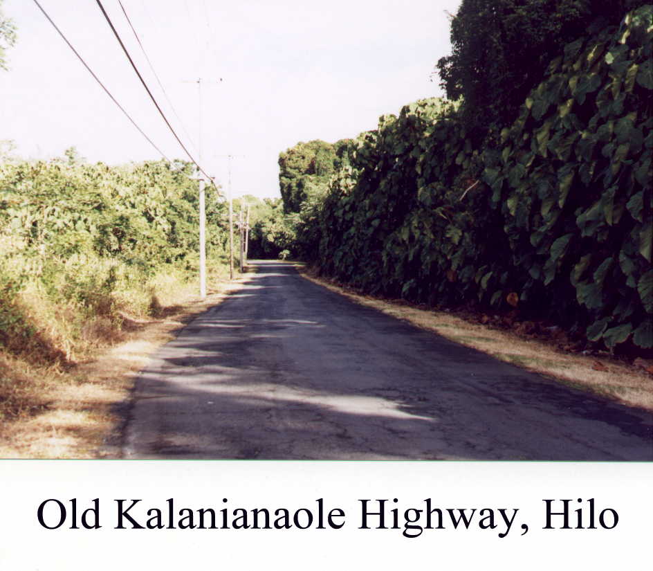
When, I finished, I remarked to a bus driver that had seen me go out, that the current was surprisingly strong, and that I almost had to really swim to get in. He said, ``I saw you go out and thought `Oh, Oh'!''.
I went snorkeling again in the afternoon where there was no sign indicating ``Strong Currents'', hoping that it there would be better viewing - it was not. Then I asked a Hawaiian who was about to go in whether any one time of the day was better than any other - answer, ``No.'' Still, it was refreshing and I did see many colourful fish, the brightest being the brilliant yellow tang. I shall go again.
After dinner, I had a long conversation with Glen Peterson. Glen is a haole student of the Hawaiian language. The word ``haole'' - pronounced ``ha oh lay'' rather than the more common ``how lay'' - had come up in conversation with Patty and Jennifer last night. I was curious about the origin, and real transliteration, of the word because of the recounting of its relation to Cook's death that Jennifer had heard, probably from an ``instant legend'' tour guide. ``Haole'' means ``without breath'', and had been applied only to corpses before the coming of the ``white god'' Cook. It is not clear why it really became applied to Cook, but it is clear that he, and his sailors, had no more sensitivity to sacred things Hawaiian than a ``haole''. Glen is also a white haired artist with a braided goatee. He was originally from East Los Angeles, and began his artistic career making custom leather belts on Catalina Island. He then made ``elegant'' fir plywood sling rockers. After several more meanderings, he ended up, as a permanent camper near Kaena on Kauai. Here, out of his tent, he ran, what the rangers called ``Glen's Leather Shop''. His bribe for the rangers were custom made leather ``Smokey Bear'' hats.
His real break came after he moved to Kona where he made a custom leather saddle bag. It took every waking, and sleeping moment of several weeks to make. He did not sell the bag, but rather photographed it, and various parts of it, for prints, greeting cards, and posters. He especially enjoys being on the beach in Kona, and meditating on the Halehau Heiau by the King Kamehameha Hotel. This is his interpretation of his early morning meditations.
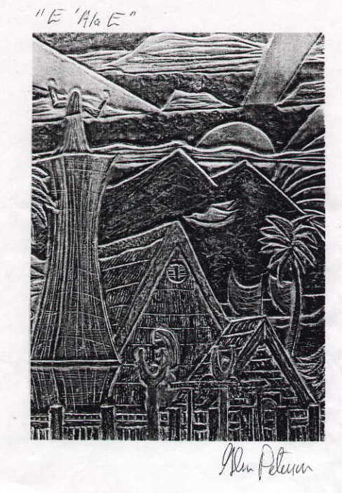
Glen has a second love, Japan and all things Japanese. He has visited Japan many times, and now has a working knowledge of Japanese. He is here in Hilo, working for Arnott's to have a place to live, so he can take some advanced classes on Japanese language and culture at UH-Hilo. He wants to be able to go back to Japan for some time, and feels that he might be able to get a student visa, if he acquires few credentials. He is a Shinto disciple, and was especially interested in my description of the diamond studded, sunrise on Fuji. The viewing of a sunrise is the seventh, and final upward step on a pilgrimage path.
Just after breakfast I went back to Leleiwi. The coral banks just north of the three gazebos appears to be the best snorkeling place on this side. It's main advantage is that it doesn't have any fresh water springs in the immediate vicinity. It is a little rough so there is some debris stirred up from the bottom - but all in all, it is the best place I have found on the Big Island. However, I have not been to some of the recommended day use parks on the Kona side.
The tour for Mauna Kea allowed me to get the ride to the Mauna Kea Visitor Center at 9000'/2800m. There was enough room to remove one seat from the van so I could easily put my bike inside. Arnott's charged me only $8.
The Saddle Road up from Hilo was relatively gentle for the 20 miles and 6000' to the spur road to Mauna Kea. We stopped there for our first acclimatisation hike.
From here, up to the visitor center, the road had some moderately steep sections (17%), but was paved all the way.
The visitor center area also includes Hale Pohaka, the residential housing for Mauna Kea summit workers. However, contrary to my previous reports, there is no campground. When I asked Dave, the visitor center manager, where I should camp, he told me ``Camping is not permitted on Mauna Kea.'' I then asked where I could go to be discreet. He then noted that the camp (buildings?) just below the center were not being used. Later he came outside to tell me that the washrooms were open 24hr and the water was drinkable.
I found a discreet place and am waiting for the sunrise to complete. The stars were not as bright as I would have hoped - the moon was half full and cast shadows. First light has been almost an hour because the sun has to rise above a high eastern ridge.
After breakfast, I packed all my stuff and left to attack the road.
I had hoped to leave all my stuff here in the ``campground''. It is clear, now that I will have to haul it up with me. First it is up about 3000'/1200m in 3 miles of dirt road. The dirt road ends at 5 miles with the last 5 miles paved. I was defeated in the first 20m. The road is gravel, but the one to two inches of sand made it impossible. I went back to the start of the gravel - the whole 20m, and unloaded my bike to try to hitch a ride. It was only 8:00am and the only cars going up were observatory employees. Just before 9:00am, I went back to the visitor center to look at their ``Silver Sword Trail'' They have imported silver swords from Haleakala on Maui. Theirs are still babies.

As I was leaving, John Furnis, the second man in the visitor center, asked me if I was riding up. I told him it was impossible with a full bike, so I was trying to hitch a ride. He invited me to leave my stuff at the visitor center. I declined, but changed my mind a few minutes later after I returned to where I had left it. I reloaded my bike and put all, but 5 litres of water, bananas, trail mix, and tools, behind the counter of the visitor center. I can't get a lighter bike - but the water still made it heavy.
I was able to get past the first section that had defeated me on a full bike but still had trouble on other steeper, sandy sections where my rear wheel would spin. It was also impossible to start on those sections. The wheel would spin before you could move the bike. I pushed up those.
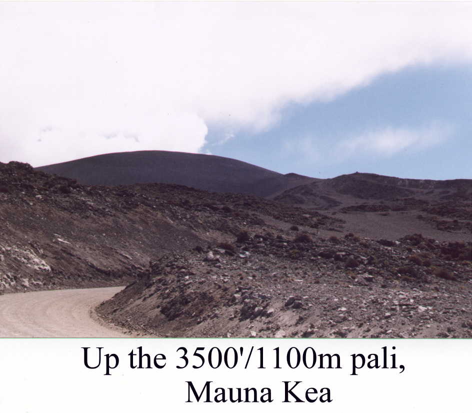
Looking back from the pali, Mauna Loa was crystal clear when I started. As I went up, clouds started to grow and the smog from the sulphur vents became more obvious.

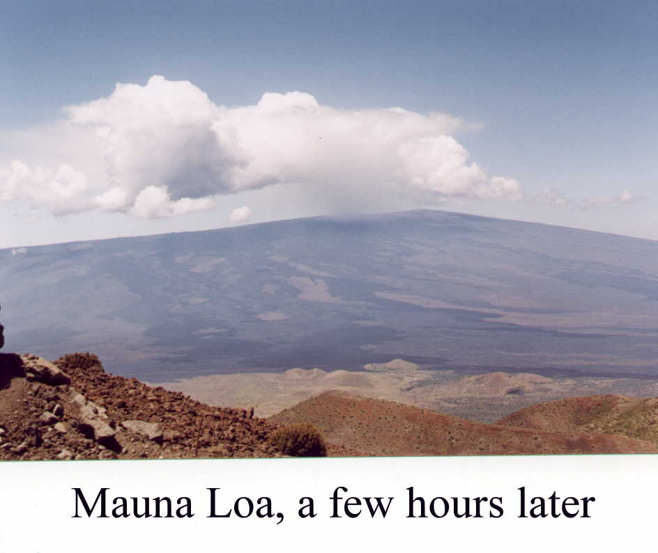
Just before the paved road began, while talking to a couple on their way up - almost all the tourists on their way up stopped to talk (none of them could have taken my full bike) -, I was dripped on. A few minutes later, it became real rain. Elsewhere in Hawaii, I would just get wet, but here, at over 12,000'/3800m, I wanted to stay dry and warm.
I stopped for a major rest/refueling where the road first became paved. The rain had stopped while I was eating, but it was clear the weather was a little strange. Just west of me there was a thunder storm - some tourist brochures say there never are thunder storms in Hawaii -, the summit of Mauna Kea was in the midst of a storm with clouds high above it. That storm moved off, but then I started to be hit with horizontally flowing snow flakes that very soon changed into rice size hail. Clouds formed and disappeared in front, and behind me. I looked back, and saw that the storm had now moved to the pali I had just climbed.


After riding short way up the road, I decided there was really no point in going any further. After clearing, the summit was back in cloud. I also had used up most of my energy, even with replenishment. As I was about to turn around, John came through the cloud on the pali, with his windshield wipers running. He asked if I wanted to join the Saturday afternoon, free observatory tour that he was guiding for the Mauna Kea Observatories. I threw my bike in the back of the station wagon, and came along. We drove to the summit where the observatories were clustered. When we arrived, there was just a smattering of snow on the ground.
The only other people on this tour were a graduate student couple from Edmonton. He was in control systems and she was in astrophysics. As we were visiting the James Clerk Maxwell Telescope, it started to snow/hail in earnest. John took us there to do Tom Lowe a favour. He wanted to set up an experiment and need someone else in the telescope while he was doing it. We were outside while he rotated the telescope in a complete circle. While we were inside, the entire complex had been covered with about 1.5"/4cm of snow. The change was dramatic. We also discovered the ``Ski Hawaii'' hill. Not only do they ski here, they have annual snowboarding championships here.
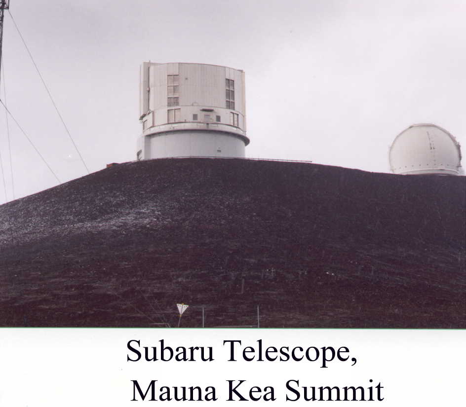


While we were visiting several other telescopes, reports from the summit caused the road to be closed. John felt that the slush would melt, so he phoned down to indicate that the road should be opened. It was then reopened for uphill traffic. John also reported back that he was ``evacuating17'' the bicyclist because the road was unsafe.
We arrived back at the visitor center at about 5:00pm to see it first covered with clouds, then clear, then covered again. At about 6:00pm, I retrieved my stuff from behind the counter, set up my tent, and made my supper. It was a bizarre day - and I did get to the top of Mauna Kea with my bike.
It was another beautiful morning. The air is really refreshing.
The ride to Hilo was, in reality, a 2 hour coast. There was only one little uphill that required me to shift to low gears. I barely peddled at all. It was cloudless as I left, and remained so until the 4000' to 2000'/600m band of clouds and rain that seems to be a normal part of the Big Island. The surprise of the morning was Mauna Kea itself. Several more peaks were white. There was much more snow last night.


At about 3000' the jungle returned, and stayed all the way to Hilo. This was an absolutely fun ride - highly recommended. I arrived back at Arnott's at about 9:30am. I am a few days early, but my tour of the Big island is complete - Mauna Kea was the final episode.
I phoned my friends Nan and Steve Jackson to warn them that I was about to arrive early. I tried again several times to confirm, but only was able to get the HawTel message that their cell phone was out of range. Finally, after I had put my bike together at the airport in Honolulu, I got Nan in her car. They are out for the evening but my garage apartment room is open.
I have now arrived, had a shower, and am settled, waiting for them to come home. I didn't see them until morning - I faded.
I rode slowly from Nan and Steve's house, near University of Hawaii, down University Ave., trying to see what I remembered from 25 years ago. There has been considerable UofH construction, and it was not my part of the campus, so it was quite strange. The two little shopping centers, at the corner of Wailae and University, were still there. Wailae is still the collection of small shops, some unfortunately empty, that I remember, but I have no idea whether they are thesame small shops. The monolithic concrete block, called the Kaimuki Shopping Center, is still much unchanged.
I was on my way to Hawaii Kai to see Virginia's apartment and snorkel in Hanauma Bay. I used to commute this way on my motorcycle every day from our house in Hawaii Kai to the University. The biggest change is Kalanianaole Highway, the only road. It has been widened, and has a ``Bicycle Lane'' shoulder, the whole way. It is a delight to ride. In 1975, I enjoyed, immensely, looking back into the valleys, seeing rainbows, as I used to ride home. Today, there were no rainbows, but the valleys, looking up into the Koolau Mountain Range, are still beautiful. The mango trees where I used to gather bags of mangos by the side of the highway are there, but now, a sidewalk runs under them. The mangos are not yet ready, and the sidewalk is much more accessible than the highway, so I suspect that pickings are not nearly as good.


After visiting the apartment and having lunch with Joyce, I went to Hanauma Bay. It has recently been taken over by the city and has become a city park. There is a charge of $1 for parking and $3 for non-residents. Although it is free, with ID for residents, Nan complained they all had to stand in the same slow line to get in. Perhaps they need a resident's line, similar to the resident's passport line at borders. Hanauma is also closed on Tuesdays. With all that said, it is still a fantastic place to snorkel - the best I know on any of the Islands. You swim amongst the fish, one to two feet away from you, with the occasional curious, or lost, fish coming up to within inches of your mask, and staring. The variety is immense and colourful. It is worth a detour, and an extra day.
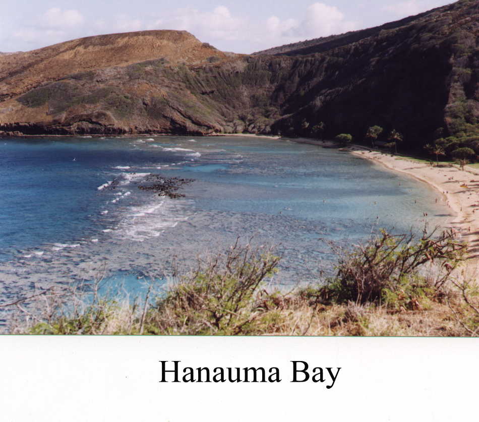
Today I rode down to Waikiki, around Diamond Head, through Kahala (Susan's ``exclusive'' residential community but couldn't find her house), and back to Waikiki to go surfing.
In Waikiki, I met an enterprising Hawaiian who had carted his board, his family, and a tent, down to the beach on his bicycle. I was inspired to go back to Steve's house, about 3 miles, to get his 9' board. I didn't have a professional bicycle surfboard carrier, so I strapped it on my backpack and pedalled down. The major problem would be, of course, the wind loading. It was not comfortable, but it was doable. One unexpected problem arose when a policeman forced me to walk on the beach sidewalk, and I started hitting some overhead trees.
Most of my spent 3 hours was spent, relaxing in the water enjoying the view of Diamond Head. The view from out in the water is unique, and inspiring. Diamond Head is laid out in front of you, without any obstructions whatsoever. It was beautiful, and not duplicated from the shore.


The 2'/4' swell predicted for today didn't materialize. Most of the afternoon was spent with slow rollers, that some, but not all, of the professionals out with me could catch. In the 3 hours there were only two really good sets. They caught me rather than me catching them. I did manage to catch another wave, but the major conclusion of the afternoon, is that after a fifteen year layoff, I had neither the power nor the technique. It was, though, a thoroughly enjoyable afternoon, followed by the 3 mile ride, up the hill to Steve's house.
Before breakfast I went across the street to Nan's neighbourhood mango tree and found two large (grapefruit sized), nicely ripe, mangos on the ground. They were delicious at breakfast, and the first ripe ones, larger than an egg, that I had seen.
After breakfast, I rode over the Nuuanu Pali to windward Oahu, and then intended to go on to Hanauma Bay to snorkel. It became clear very quickly that the 3 hours in the sun on my bare legs had done a real job on them I decided that it would be imprudent to expose them to any more sun at all. The Nuuanu Pali is about 1200' and separates leeward and windward Oahu. On the windward side, Kailua and Kaneohe, the pali is almost a shear cliff. On the Honolulu side it is much gentler. About half way up, the bicycle route changed to the old pali highway, now called Nuuanu Pali Road. This was a wonderful, almost traffic free, road amongst huge banyans, most covered with vines, and paralleling the Nuuanu Stream. It was a real delight. It came out at the point where the road flattened and started down towards the edge of the Pali, now defined by the Pali Lookout.


The original 1897 road goes down from this point while the current road goes through a tunnel just below. I was told by two guys, one a native of Kaneohe, that the old road was passable on a bike, and the gate guarding it was not locked. This road averaged an 8% grade and hung right on the side of the cliff. The views in both directions were spectacular.


After a couple of miles, the road dead ended in a huge pile of boulders. There was no possibility of getting to the new Pali Highway just below - it was on a viaduct, separated from the bank. I was worried that I might have to back up, but found a trail, behind a falling rock screen. I had to carry the bike over the boulders, but it was possible. This trail went in and out of the stream valleys as it dropped through hao thickets. It was not difficult, and may even have been rideable by some intrepid mountain bikers. It was cool and calm, except for the noise form the new Pali Highway just below. Eventually, it met the 9.6mile trail to Waimanalo, and then angled out to a trail head on the road. On the way down there was a sign that said, ``Bicyclists should yield to Hikers''. The ``trail'' at this point was steps defined by plastic composition rails. It did not look like an easy or fun ride.

From here it was down to the Kalanianaole Highway, that leads back to downtown Honolulu. The surprise here was the prosperity of Waimanalo - there were new houses and businesses. This is a ``Hawaiian Homelands'' town, and has been traditionally (mid 70s) depressed, and the center of Hawaiian Independence. Makapu`u, is one of the most popular body surfing beaches on the island. It seemed much bigger than I remember when I took Peggy there. It now, also boasts, a lifeguard.

After going around the end of the island. I stopped to look if Queen's Beach (Sandy Beach) was as dangerous as it had been in the 70s. Then, there were an average of two paraplegics a year. When I mentioned this to the lifeguards, their comment was ``Bout the same.'' The surf was reasonably gentle today, but it was showing some potential for danger.

From there I went to Kahala, and around Diamond Head, and into Waikiki. It was in Waikiki that the distressing event of the day took place. I was pulled over by a policeman for riding on the sidewalk. In addition to giving me a $42 ticket, he threatened to confiscate my bike because it was not registered in Hawaii, and hence was not allowed to be ridden on public roads. I told him I was leaving tonight, and he relented, saving us both a tremendous amount of grief. It is hard to believe that you can't bring a bike into Hawaii and ride it on the roads. If this is the case, then all the Ironman competitors are breaking the law, not to mention a dozen or so other bicycle tourists that I saw on my travels. Waikiki is a kingdom unto itself. It is really important for Hawaii that tourists feel safe here. I suspect that laws, that are universally unenforced in the rest of the state, are rigidly enforced here.
Steve drove me to the airport to catch my 12:45am flight. The flower lei stands at the airport are still the best place to buy flower leis to take home. You can buy them in town but they are more expensive, being aimed at the kamaaina party market.
The flight home was appropriately uneventful with little gastronomic, social, or entertainment excitement. My two arrivals (Toronto and Montreal) were on time, and there were no complaints from Agriculture Canada about my agricultural products - macadamia nuts, sugar cane, or ironwood. My bags all arrived safely. In the important things, CP did well.
It was a good trip. I rode about 700 miles (1100km) on the Big Island and about 100 miles (160km) on Oahu. I learned a lot about the Hawaiian language, and now have a feel for almost all of the Big Island. There is still much to experience on the Big Island, but it would take living there.
People would ask me about the changes in 20+ years. Of all the 5 major islands, Hawaii has probably changed least, with most of it being cosmetic. I was most struck by the architectural changes in Honolulu, and its suburbs. ``Up country'' Hawaii has disappeared in Oahu, Maui, and Kauai, but still graciously, and in some cases, with poverty, on Hawaii.
The people were friendly, inquisitive, and mostly supportive. There were possibly three exceptions - on the road to Ho`okena, a shout from kids in a car ``Get off the road!'', and a ``work to rule'' policeman in Waikiki.
Bicycle camping and touring of the Big Island is exhilarating and rewarding. Most, but not all, of the roads have shoulders. The biggest problem is getting permits for camping. The Camping Permit system in Hawaii is primarily intended to discourage people from living at the Beach Parks. The distances on the island are sufficiently small that it is quite feasible for car tourists to get the appropriate permits. However, this is not true for bicyclists. Hilo, Kona, and Waimea can become impossibly far away on a bicycle.


1I discovered while I was there that it is possible to buy individual coupons from travel agents, and even from the Backpacker's Hostel in Honolulu, or Arnott's Lodge in Hilo - next time, maybe.
2On this trip I discovered that I had been spelling, and hence, mispronouncing, this name for 35 years. I spelled it Halema`uma`u
3Later, at the Samuel Spencer Beach Park where I camped, I discovered another guy who was trying to give away half of his gallon container of fuel.
4The words ``pahoehoe'' and ``a`a'' for lava have now become the technical terms for these two different types of lava.
5``Wai'' is ``water'' in Hawaiian. Water is critically important in Hawaii, and there is a great repetition of ``Wai...'' names over in the islands. This ``Waimea'' is also known as ``Kamuela'' to distinguish.
6All ``w''s in the middle of a word are pronounced as a ``v''. Thus ``Hawi'' is ``Havi'' and ``Hawaii'' is ``Havaii''
7A ``pali'' is a cliff, or more accurately, an escarpment, usually between a high plain and some lower flat area. The Nuuanu Pali separates windward (Kailua and Kaneohe) from Honolulu. The Honolulu side rises rather slowly and the Kaneohe side drops off precipitously.
8Local information from a bicyclist from Kurtistown, just south of Hilo, said the road was paved with wide shoulders, not too steep, to 9000'. There was a campground there for the assault to the summit on the gravel road. Some guys went up and down in one day but this bicyclist thought they were crazy.
9The ' that you see in Hawaiian words such as Waipi`o is an important part of Hawaiian language spelling. It represents a glottal stop in the pronunciation, Thus ``pi`o'' is not ``peeo'' but rather ``pee oh''. I must admit that I forget to include the ' in all my spellings.
10Even the postcards show water in only one of the falls.
11The current generation of 4wd Suzuki Trackers are only large enough to carry their gas tank.''
12That was the ``official line''. Off the record, he said ``If someone pedaled all the way up the hill without a permit, I almost certainly would have missed seeing them.''
13I learned later that it was a ``Kalij Pheasant'' - introduced from somewhere.
14Macadamia Nut trees take almost 20 years to bear nuts.
15A ranger at the visitor center told me that he had been standing at the end of the road, and was blinded for about 3 weeks by a piece of flying glass.
16``Ono'' was originally the name of a fish, prized by the Alii. It has since become the Hawaiian word for ``good''.
17Employees are not allowed to give rides up the
mountain, but they are allowed to ``evacuate'' people from the mountain.